Thursday, December 30, 2021

Beauties of Someshwara


Day-1:
It was year end and I had planned to visit some places which was in my list. Koodlu theertha was left somehow. I had tried to visit in August 2021 trip but it was closed due to heavy rains. 
Fall and valley

Started off from Mysore early morning and reached the Koodlu gate around noon. Board here shows 15kms to this place. 

Took this route, was happy to see very good road until the rough patch started. At one place was worried and stopped if any car could go beyond.

A person who had come in Honda Activa saw me and stopped. He had visited few times and was confident to tell that any small car can go till the parking point. Feeling motivated, I proceeded and reached parking point.


There is Forest gate here, they will take necessary information and will provide permission to enter. Visitors are allowed to enter latest by 3pm. Soon started walking and in about 45min reached to see mighty beauty. 

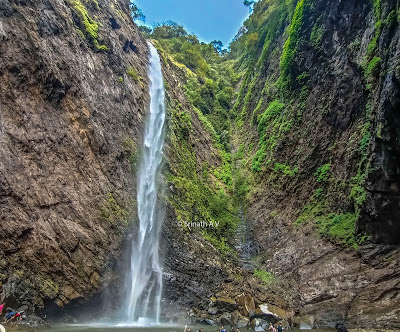
Koodlutheertha falls

Weather was perfect sunny day, many people were enjoying play in the shallow waters of Koodlu. Single fall of about 300 ft was spectacular.

Spent time in swim, walked around the place to take different views of the fall. Started to descend back and reached parking lot.

Started my way back to Hotel. Made a pit stop near Varanga-Kabbinale road. There is a fall very close to this road. 

Took photo and returned back to Hotel.

Road side waterfall


Day-2:

I enquired about Vanake abbi (Onake abbi) at Someshwara and found that Forest department is giving permission. Without any second thought planned this trek for the next day. Reached Someshwara Forest office around 8:30am and got all formalities done. Our local guide Srinivas and his friend were ready.

Distant Onake abbi falls


We parked car at small village,  and could see distant Onake abbi like this.

There was clear trekking route, and soon started our ascent. Route is steep climb up, little climb down and up again. By 90min we could have the first glimpse of fall. It is roughly about 3km one way.

After this point, it is about 15min walk along the stream which is more difficult to cross slippery rocks.

Tall straight trees - on the way to Onake abbi


We could see lot of straight trees like this. Forest was dense and sunlight could fall very little to the ground.


First glimpse of fall


After climbing up the stream we were in front of this amazing 500ft waterfall. All our tiredness  vanished after seeing this and drinking chilled natural water.
Closer view of fall

Front view of the bottom step


Spent some time here and started to descend back. 

By half way, we could hear sound from another stream and could see another fall behind the trees. Our guide knew about it and told as Meenabbi falls.

Upon our request, he tried to find a way to reach this. Short descend towards mountain, we were are the stream. We had to walk another 30 along this stream. There were no path and with great difficulty we could reach this place. 

Meenabbi falls

Closer view of Meenabbi


We took some time in taking photos/videos and reached back to parking lot. Since there was some time, our guide took us to Chitrabbi falls near Kabbinale. Thanked Srinivas and Ranjan for coming with us and showing 3 falls and made our day.
Chitrabbi falls


Note: Since Onake abbi is coming under Forest range, it is compulsory to take necessary permission to enter. Walking along and crossing stream is necessary to reach the base of falls. So, post monsoon is best time to visit.


Wednesday, July 28, 2021

Monsoon Drive 2021

Day-1: 

It is always nice to capture waterfalls when they are in full flow. Belkal Theertha was in my list since long. I started from Karkal,  drove through Shankaranaraya-Jadkal-Belkal. The road narrowed and narrowed as I passed villages, finally near Temple it was hard to manage this small bridge and immediate turn.

The last point on the Concrete road is the Parking lot, luxury of car drive ended here. 

This waterfall is known as Govinda Theertha by locals, they go quite frequently there and believe taking dip here is very auspicious.

It was very cloudy and monsoon was very active for the last few days. Started to walk from there and within 2 minutes I was at the Forest check point. Providing necessary information, took entry ticket and camera tickets and started to walk.

Based on my request, one of the local came along with me. It was a week day and we were the only 2 people in the forest.

The walking trail is quite simple as there is no deviation in the path. It took about about 1 hour to see the first glimpse of fall.


Waterfall seen from Temple

Ascending up for few minutes, I could see the fall. Water splash and rain both were exchanging turns quite well and it was hard for me to take good photos/videos.

I waited for more than 45min, that too didnt help me to get clear views. 

  Managed to climb up carefully to go little side of the fall to avoid water splash. After taking many pics and videos, started back. 


Came back to the parking lot, had my packed food, thanked the villager and returned back to Karkala.
Closer view of the fall


Day-2:
Morning had walk to Ananthapadmanabhaswamy temple, which is 450 years old. It was nice to read about it. Calm and beautiful ambience made a perfect start of the day.
450 year old temple at Karkala


Had breakfast at Hotel Prakash, packed food and started my drive towards Hebri. I had planned to visit Kudlu theertha. I was at the deviation point 9:30am. Board mentioned that Falls is closed due to heavy rain. Talked to Forest guard there and he told that way to falls is crossing river and due to high downpour, entry is prohibited. I was totally disappointed about my day plan. 

Thought for a while, done some quick browsing and planned to drive towards Tombattu village. I had heard there are few waterfalls near this.

From Someshwara, drove towards Halady and took right turn at Halady junction towards Amasebailu. Finally it was about 11pm I reached Tombattu village. It was raining heavily and went to near by shop to enquire about waterfalls.

As usual I got initially de-motivating replies about the waterfalls, not good to go in rains etc. After talking for a while, seeing my interest Mr. Udupa came forward to help me. He requested his friend to along with me. This region too is coming under Wildlife area and hence it is required to take permission.

From the last house, it is about 1 hour steep ascent. There is literally no trail or the water sound. Without guide, it is impossible to reach this place. With all the leech bite, we were finally at the base of fall.
HK falls
  Enjoyed serene ambience, wandered within safety limits to take photos of different views and returned back to village.


Seeing my interest, Mr. Udupa told about a small waterfall near to village and we went without wasting any time.
Mr. Udupa was very kind enough to help a stranger. Thanked him and returned back to Karkala. I have travelled to many remote villages in western ghats. Feel happy and thankful to great  people who help strangers whole heartedly.

Small waterfall nearby village


Towards Hosangadi route, I visited Irkegadde, very nice place.

Irke gadde

Irke gadde


Day-3:
Google maps indicated a small cascade near by Karkala. I followed map and soon was at calm and quite place Durga falls. Could see blue sky for a short while, managed to get good picture.
Durga falls

Drove towards Hornadu-Kalasa and returned back to Mysore. 

Thanks to Rajesh Naik and Aravind G.

Wednesday, January 27, 2021

Visit to Adi Subramanya and Devaramane

 I had heard of very old temple at Agrahara, Gonibeedu from my friends. It is Subramanya temple and known as Adi Subramanya temple, planned a day trip to this place on 26-Jan-21.


When travelling from Belur, after Gonibeedu junction, there is arch on the left side. 2kms towards this will lead to a beautiful and calm temple.

Hemavathi river in front of temple


Lake in front of temple
Planned to visit Devaramane to spend rest of our day. Drove towards Mudigere and took the left deviation before Mudigere post which leads to Devaramane. 

With narrow roads and little mud roads reached Kala Bhairaveshwara temple at Devaramane village.


Panaroma view at Devaramane

Visited temple, had lunch, took some rest and started to explore the view points.


Even though it was very hot and humid, got good pictures of the mountains and valleys.


View of Ethina bhuja peak from Devaramane gudda


Distant view of Ethinja bhuja gudda


View of distant mountains


We thought of taking different route to descend, took the road towards Banakal which is 12km from Devaramane. Road was in good condition.


Got amazing views of the mountain ranges, reached Banakal and drove back to Mysore.


Info:

This place is very good for mountain views, valleys and picnic, also suitable for day trip.

Based on your capacity you can choose the mountain to climb.

19kms from Mudigere Handpost

12kms from Banakal

Good for Children/elders as some places are having easy access from vehicle parking.


Saturday, December 12, 2020

Mullianagiri & Ukkada waterfall

 I was planning for a short trek to relax form long working hours at home. Started searching any unvisited waterfalls near Chickmagalur, Ukkada seemed to be attracting.


Thought of capturing morning photos from Mullianagari and started off from Mysore early morning. Without much traffic, reached Chickmagalur at 6:30am. Had coffe and packed Idlis-Kesari bath from Mayura hotel and started towards giri. Drive was cool, sky was clear and very good for photos. 


Soon reached top and started taking photos. Blue sky-green mountains were amazing.

View of Bababudangiri range was very nice.


Another view of mountain range


Had breakfast and started towards Ukkada. I had seen during my previous trips at Atthigundi, one road deviates to another mountain side and looked good.

This was the scenic route which leads to Muttodi side. This narrow road is good till Halasina khan estate. After that the descent was very rough road and took lot of time.


I reached Koloagave and enquired about this falls and luckily got help from a person Karthik.


We took road towards Ukkada village and reached the stream.

This waterfall is inside a private estate and there is no sign board. One has to get help from others or try routes walking inside estates.

Walking about 15min, we were at the waterfall.


Felt sad that people had thrown plastics, bottles.

Took pictures and returned back.


Drove back towards Muttodi and reached Mysore by night.


Sunday, January 19, 2020

Devkar falls / Vajra falls

Devkar falls was in my list since long time. Due to various reasons, I was not able to make it. Started my internet search about this for latest info/routes. Understood that there are 2 routes to reach, one is via Karwar-Kadra side to reach Devkar village and the second route was via village Eerapura.

Devkar falls is also called Vajra falls or Kanoor falls. Devkar villagers are rehabilitated else where and this make it quite difficult to visit Devkar village from Kadra side.

I took night bus Rajahamsa bus from Mysore to Sirsi. After morning fresh up, started bike drive towards Yellapura.

It was very cold and foggy too.

Had break fast at Shanbagh restaurant, packed food for the day and started towards village Eerapura. Reached around 10am and started to find any guide. Roamed near School, near by houses but all were busy with their work. Time was rolling and I started doubt if I can make it!!!

I went to one house (Bhattra mane) which turned into be motivating one. He was very happy to hear from me, about my interest and took me to another place near by to find any people. Senior villagers were advising that Bende ghatta route is very far and too time consuming. Bhattru had heard that some trekkers have made descent from Kanoor side. After about 30min of discussions and wait, I finally got a person who was from Devkar village but settled here. He has not seen the place but understood the directions given by others. Soon, we started towards Kanoor village.

Sign board on SH6 after Basal village
Took SH6, just after village Basal we see this sign board.

Quickly we reached the parking point, where our vehicle comfort ended and the real test begun.

We walked few minutes, reached the river and few meters away was the mighty fall of about 200m. View was amazing with lush green Kali river valleys. While I was busy taking snaps, guide was planning for the route.

Water rushing to fall

View of Upper section

We didnt waste much time on top and started our descent at 12:30pm.

There was walking trail for some distance and it disappeared. Dense forest was dry and sun was unable to touch the ground.

Entire descent was full of slippery path, we held small plants, rocks, trees for our support along our way.

After 1hour of walk, we were able to hear water sound. The final stretch was like slide.
View of vertical fall and downstream

At last, we reached river at 2:30pm and could see distant Devkar falls. We quenched our thirst and had lunch.

We went towards the fall to get good photos and enjoyed serene nature. Voice of birds, water was very relaxing.


Devkar falls / Vajra falls


Route map of our Trek
Close view of upper section
Our guide wanted to try other faster route.

We had descended along the way shown in Yellow arrow mark in the picture.

He planned towards West direction. At 3:30pm, we started ascent in the direction shown in Red arrow mark. We walked almost about 1hr and were hit by huge rocks. Guide tried a lot of alternates but could not go ahead.

As we were losing time, we descended back to river to take back the same route. I was tired due to this challenging terrain. Having small snacks break, we started our ascent at 5:30pm.
Snap of our  trek in darkness

Guide was alerting about darkness and we should touch the mountain top before dark. I was already exhausted but pressurised myself to make small moves to keep the ascent continuous. With great difficulty and lot of stops, I managed to reach top mountain. By this time, darkess had already captured and we could not find our path.

It was mere direction sense of our guide, we switched on our mobile lights and walked in darkness. We came to a small stream which had little water, quickly quenched our thirst. We guessed that this stream would join the main river and so we followed the stream. There were lot of obstacles to stream path, we went around trees to come back to stream. Finally at 7:15pm, stream crossed a small walking trail. We soon realised this was our path. Thanked god and took the trail to reach parking place.

We soon reached SH6 and by 8pm we were at the village. By this time, villagers were worried about us and seeing us, they felt relaxed. Thanked villagers, stayed at Bhattru mane and took rest. Devkar falls challenging terrain trek was fruitful and gave good memories.

Kali river valley

Bhattru mane was awesome, thanked him and started my journey back.

Took night journey and back to Mysore with lot of photos, and memories about Devkar.

Summary:
Devkar falls is really Trekkers paradise. Medium to Hard trek.

Heard from villagers that Devkar village is almost vacated. Not sure about the way from Karwar-Kadra side.

Trail from Eerapura - Bende ghatta is long route and may be possible with help of guide.

This route which I took, is impossible during rainy and post rainy season, possible during dry seasons. Has to be planned with guide as there are no marked routes.

Happy and safe trek.